Pursuant to the Oklahoma Local Development Act, 62 O.S. § 850, et seq. (“Act”), notice is hereby given to all interested persons that the City Council of the City of Claremore will hold two public hearings regarding the proposed Claremore Mustang Data Center Economic Development Project Plan (“Project Plan”). The first public hearing will be held in the City Hall Council Chambers, 104 S. Muskogee Ave., Claremore, OK 74017, at 6:00 p.m. on May 4, 2026, and will be for the purpose of providing information, including an analysis of potential positive or negative impacts, and answering questions regarding the proposed Project Plan. The second public hearing will be held in the City Hall Council Chambers, 104 S. Muskogee Ave., Claremore, OK 74017, at 6:00 p.m. on May 18, 2026, and will be for the purpose of giving members of the public an opportunity to be heard prior to any vote on the proposed Project Plan.
The Project Plan is a project plan as defined under the Act. The Project is being undertaken by the City of Claremore (“City”) to provide an economic structure and financial support necessary to facilitate the development of a large-scale data center campus within the Project Area, generally located northwest of the South Highway 66 Expressway, in order to promote economic growth, job creation, and increased regional business activity. Financial support for the Project will primarily be provided through the establishment of three incentive districts (the “Incentive Districts”), which will provide ad valorem tax exemptions to encourage development, along with negotiated payments in lieu of taxes (PILOT Payments) and community betterment payments to support public services and infrastructure. No new or increased taxes are involved.
The Project Area and Incentive Districts are coextensive with each other, as shown in Exhibit A of the Project Plan and described in Exhibit B of the Project Plan. The Incentive Districts would be given appropriate numerical designations and dates of creation within ten (10) years of the City Council’s adoption of an ordinance approving the Project Plan following the conclusion of the second public hearing, should such ordinance be adopted. The boundaries of the Project Area and the Incentive Districts are illustrated and described below.
Notice of Public Hearing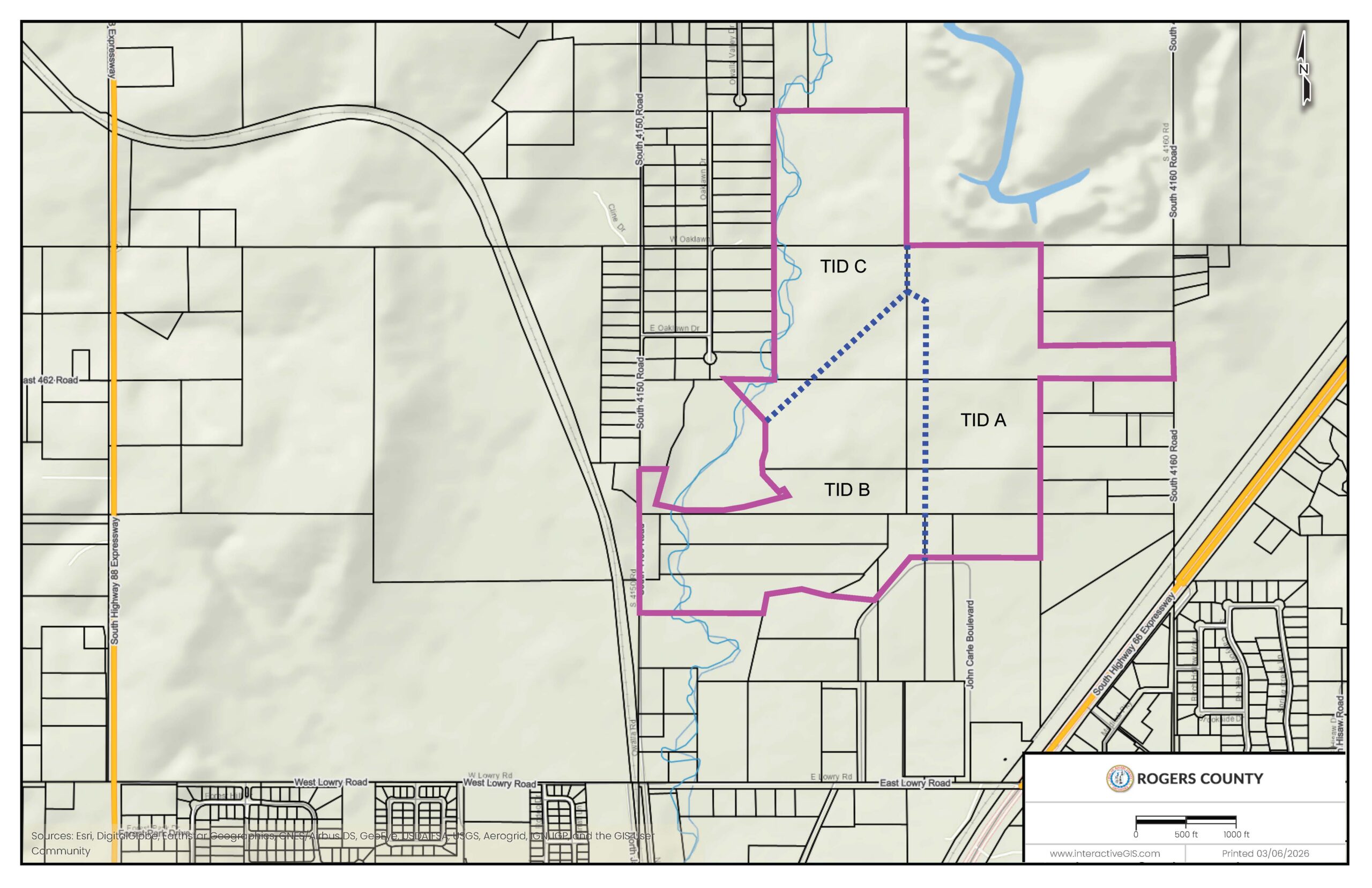
The Project Area can be described, simply, as the full area coextensive with the boundaries of all three Incentive Districts listed below.
Incentive Districts Legal Descriptions
All that part of a tract of land lying in the East half (E 1/2) of Section Thirty-Three (33), Township Twenty-Two (22), Range Sixteen (16) East of the Indian Base and Meridian, Rogers County, Oklahoma, more particularly described by Gregory Chad Weller, Oklahoma PLS-2075 of Olsson, LS-114, on March 24, 2026, as follows:
BEGINNING at the Northwest corner of the Northeast Quarter (NE 1/4) of Section Thirty-Three (33), Township Twenty-Two (22) North, Range Sixteen (16) East; thence on the North line of the Northeast Quarter (NE 1/4) of said Section North 88 degrees 44 minutes 12 seconds East a distance of 1,319.40 feet to a point; thence departing said line South 01 degrees 29 minutes 57 seconds East a distance of 990.28 feet to a point on the North line of the South Half (S 1/2) of the South Half (S 1/2) of the Northeast Quarter (NE 1/4) of the Northeast Quarter (NE 1/4) of said Section; thence on said line North 88 degrees 20 minutes 55 seconds East a distance of 1,319.80 feet to a point on the East line of the Northeast Quarter (NE 1/4) of the Northeast Quarter (NE 1/4) of said Section; thence departing said South line on said East line South 01 degrees 29 minutes 57 seconds East a distance of 330.09 feet to a point, said point being the Southeast corner of the Northeast Quarter (NE 1/4) of the Northeast Quarter (NE 1/4) of said Section; thence departing said line on the North line of the South Half (S 1/2) of the Northeast Quarter (NE 1/4) South 88 degrees 20 minutes 55 seconds West a distance of 1,319.65 feet to a point, said point being the Northeast corner of the Southwest Quarter (SW 1/4) of the Northeast Quarter (NE 1/4); thence departing said line South 01 degrees 29 minutes 54 seconds East a distance of 1,319.92 feet to a point, said point being the Northwest corner of the West Half (W 1/2) of the Southeast Quarter (SE 1/4) of said Section; thence departing the South line of the Northeast Quarter (NE 1/4) South 01 degrees 29 minutes 54 seconds East a distance of 448.49 feet to a point; thence South 88 degrees 35 minutes 49 seconds West a distance of 1,067.90 feet to a point; thence North 01 degrees 35 minutes 00 seconds West a distance of 2,439.01 feet to a point; thence North 69 degrees 00 minutes 50 seconds West a distance of 268.28 feet to a point on the West line of said Northeast Quarter (NE 1/4); thence on said line North 01 degrees 30 minutes 50 seconds West a distance of 550.82 feet to the POINT OF BEGINNING.
Contains 3,891,301 Square Feet, or 89.3320 Acres, more or less.
All that part of a tract of land lying in Section Thirty-Three (33), Township Twenty-Two (22) North, Range Sixteen (16) East of the Indian Base and Meridian, Rogers County, Oklahoma, more particularly described by Gregory Chad Weller, Oklahoma PLS-2075 of Olsson, LS-114, on March 24, 2026, as follows:
COMMENCING at the Northeast corner of the Northwest Quarter (NW 1/4) of Section Thirty-Three (33), Township Twenty-Two (22) North, Range Sixteen (16) East; thence on the East line of the said Northeast Quarter (NE 1/4) South 01 degrees 30 minutes 50 seconds East a distance of 550.82 feet to a point, said point being the POINT OF BEGINNING; thence departing said line South 69 degrees 00 minutes 50 seconds East a distance of 268.28 feet to a point; thence South 01 degrees 35 minutes 00 seconds East a distance of 2,439.01 feet to a point; thence South 88 degrees 35 minutes 49 seconds West a distance of 71.97 feet; thence in a Southwesterly direction, on a tangent curve to the left, whose initial tangent bears South 88 degrees 35 minutes 49 seconds West, having a radius of 280.00 feet, through a central angle of 48 degrees 46 minutes 06 seconds, an arc distance of 238.33 feet to a point on a tangent line; thence South 39 degrees 49 minutes 43 seconds West a distance of 391.69 feet to a point; thence North 88 degrees 15 minutes 57 seconds West a distance of 489.93 feet to a point; thence North 77 degrees 55 minutes 01 seconds West a distance of 248.50; thence South 78 degrees 31 minutes 08 seconds West a distance of 390.00 feet to a point; thence South 09 degrees 55 minutes 48 seconds West a distance of 155.70 feet to a point; thence South 88 degrees 33 minutes 02 seconds West a distance of 1,204.45 feet to a point on the West line of the Southwest Quarter (SW 1/4) of said Section; thence on said line North 01 degrees 29 minutes 34 seconds West a distance of 334.43 feet to a point; thence departing said line North 88 degrees 40 minutes 02 seconds East a distance of 201.45 feet to a point; thence North 00 degrees 57 minutes 46 seconds West a distance of 46.56 feet to a point; thence North 01 degrees 26 minutes 28 seconds West a distance of 599.63 feet to a point on the North line of the Southwest Quarter (SW 1/4) of said section; thence on said line South 88 degrees 39 minutes 32 seconds West a distance of 202.42 feet to a point on the West line of said Southwest Quarter (SW 1/4); thence departing said North line on said West line North 01 degrees 29 minutes 34 seconds West a distance of 444.37 feet to a point; thence departing said West line North 88 degrees 39 minutes 32 seconds East a distance of 247.12 feet to a point; thence South 15 degrees 14 minutes 43 seconds West a distance of 232.20 feet to a point; thence South 15 degrees 14 minutes 43 seconds West a distance of 21.13 feet to a point; thence South 11 degrees 31 minutes 18 seconds West a distance of 139.89 feet to a point; thence South 82 degrees 46 minutes 00 seconds East a distance of 340.43 feet to a point; thence South 89 degrees 20 minutes 11 seconds East a distance of 184.52 feet to a point; thence North 82 degrees 44 minutes 17 seconds East a distance of 340.63 feet to a point; thence North 72 degrees 07 minutes 00 seconds East a distance of 487.30 feet to a point; thence North 40 degrees 16 minutes 10 seconds West a distance of 76.21 feet to a point; thence South 70 degrees 23 minutes 08 seconds West a distance of 59.24 feet to a point; thence North 46 degrees 09 minutes 52 seconds West a distance of 226.93 feet to a point; thence North 11 degrees 57 minutes 01 seconds West a distance of 61.77 feet to a point; thence North 11 degrees 57 minutes 01 seconds West a distance of 45.48 feet to a point; thence North 16 degrees 11 minutes 28 seconds
East a distance of 135.86 feet to a point; North 03 degrees 17 minutes 56 seconds West a distance of 273.58 feet to a point; thence North 48 degrees 25 minutes 46 seconds East a distance of 1,855.92 feet to the POINT OF BEGINNING.
Contains 5,009,878 Square Feet, or 115.0110 Acres, more or less.
All that part of a tract of land lying in the Southwest Quarter (SW 1/4) of Section Twenty-Eight (28), Township Twenty-Two (22) North, Range Sixteen (16) East and also lying in Section Thirty-Three (33), Township Twenty-Two (22) North, Range Sixteen (16) East of the Indian Base and Meridian, Rogers County, Oklahoma, more particularly described by Gregory Chad Weller, Oklahoma PLS-2075 of Olsson, LS-114, on March 24, 2026, as follows:
BEGINNING at the Northeast corner of the Northwest Quarter (NW 1/4) of Section Thirty-Three (33), Township Twenty-Two (22) North, Range Sixteen (16) East; thence on the East line of the Northeast Quarter (NE 1/4) South 01 degrees 30 minutes 50 seconds East a distance of 550.82 feet to a point; thence departing said line South 48 degrees 25 minutes 46 seconds West a distance of 1,855.92 feet to a point; thence North 43 degrees 36 minutes 35 seconds West a distance of 580.68 feet to a point on the South line of the Northwest Quarter (NW 1/4) of the Northwest Quarter (NW 1/4); thence on said line North 88 degrees 42 minutes 10 seconds East a distance of 487.82 feet to a point; thence departing said line North 01 degrees 30 minutes 16 seconds West a distance of 1,322.63 feet to a point on the North line of the Northwest Quarter (NW 1/4) of said Section, said line also being the South line of the Southwest Quarter (SW 1/4) of Section Twenty-Eight (28), Township Twenty-Two (22) North, Range Sixteen (16) East; thence departing said line North 01 degrees 30 minutes 16 seconds West a distance of 1,322.63 feet to a point; thence North 88 degrees 16 minutes 24 seconds East a distance of 1,321.57 feet to a point on the East line of Southwest Quarter of said Section Twenty-Eight (28); thence on said line South 01 degrees 30 minutes 50 seconds East a distance of 1,334.02 feet to the POINT OF BEGINNING.
Contains 3,344,432 Square Feet, or 76.7776 Acres, more or less.